Groma
From Inventions
| (One intermediate revision not shown) | |||
| Line 7: | Line 7: | ||
|data= | |data= | ||
| - | |descrizione= Instrument of ancient origin formed of a vertical rod surmounted by a cross with plumb lines at the ends, used by the Romans (as well as the Egyptians) to trace orthogonal alignments. The instrument was used in the new division of land into plots after having determined the directions east-west (''decumanus'') and north-south (''cardus'') by means of the ''gnomone'' and ''sciotherum''. This was done by placing the gnomon at the centre of a circle and marking the points touched on the circumference by its shadow before and after midday. The rope joining the two points represented the east-west direction, while the line extending from the centre to the median point on the rope represented the north-south direction. Starting from this first plotting, the surveyor could create an orthogonal grid on the territory by sighting the plumb lines of the groma as it was moved to the various established points. The groma corresponds in fact to the modern [[ | + | |descrizione= Instrument of ancient origin formed of a vertical rod surmounted by a cross with plumb lines at the ends, used by the Romans (as well as the Egyptians) to trace orthogonal alignments. The instrument was used in the new division of land into plots after having determined the directions east-west (''decumanus'') and north-south (''cardus'') by means of the ''gnomone'' and ''sciotherum''. This was done by placing the gnomon at the centre of a circle and marking the points touched on the circumference by its shadow before and after midday. The rope joining the two points represented the east-west direction, while the line extending from the centre to the median point on the rope represented the north-south direction. Starting from this first plotting, the surveyor could create an orthogonal grid on the territory by sighting the plumb lines of the groma as it was moved to the various established points. The groma corresponds in fact to the modern [[Surveyor's Cross |surveyor's cross]]. |
|componenti= | |componenti= | ||
| Line 28: | Line 28: | ||
|strumentiesistenti= | |strumentiesistenti= | ||
| + | - The Science Museum, London<br> | ||
| + | [http://www.ingenious.org.uk/See/?s=S1&ObjectID={5E19F894-FB7F-6B02-3D6D-4C93A6C795CD}&source=Search&target=SeeMedium The Science museum, inv. 1926-369]<br> | ||
| + | |||
|link= | |link= | ||
| + | http://legioneromana.altervista.org/ita/news.php?subaction=showfull&id=1142083778&archive=&start_from=&ucat=11& (Italian)<br> | ||
| + | http://www.baden-powell.it/ep/125/Groma.pdf (Italian)<br> | ||
| + | http://www.terrapontina.it/territorio/centuriazione/index.htm (Italian)<br> | ||
| + | http://www.bbc.co.uk/dna/h2g2/brunel/A24591099 (English) | ||
| + | |||
|immagini= <gallery widths=230 heights=368 perrow=3> | |immagini= <gallery widths=230 heights=368 perrow=3> | ||
Current revision as of 07:41, 8 September 2010
Name in use since antiquity, derived from the Greek gnomon (one who knows), through the Etruscan cruma.
Contents |
Description
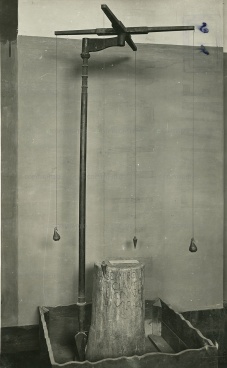
Instrument of ancient origin formed of a vertical rod surmounted by a cross with plumb lines at the ends, used by the Romans (as well as the Egyptians) to trace orthogonal alignments. The instrument was used in the new division of land into plots after having determined the directions east-west (decumanus) and north-south (cardus) by means of the gnomone and sciotherum. This was done by placing the gnomon at the centre of a circle and marking the points touched on the circumference by its shadow before and after midday. The rope joining the two points represented the east-west direction, while the line extending from the centre to the median point on the rope represented the north-south direction. Starting from this first plotting, the surveyor could create an orthogonal grid on the territory by sighting the plumb lines of the groma as it was moved to the various established points. The groma corresponds in fact to the modern surveyor's cross.
Bibliographical Resources
Dilke, Oswald Ashton Wentworth. The Roman land survayors: an introduction to the agrimensores. Newton Abbot, David and Charles,
1971.
Kiely, Edmond R. Surveying instruments: their history, Columbus, Carben surveying reprints, 1979.
Rossi, Giovanni. Groma e squadro ovvero Storia dell'agrimensura italiana dai tempi antichi al secolo XVII, Roma, Ermanno Loescher, 1877.
Rykwert, Joseph. The idea of a town. Princeton (N.J.), Princeton university press, 1976, pp. 49-50.
Rykwert, Joseph. L'idea di città: antropologia della forma urbana nel mondo antico, Torino, Einaudi, 1981.
Thulin, Carl Olof. Die Handschriften des Corpus agrimensorum romanorum, in «Abhandlungen der Königlich Preussischen Akademie der Wissenschaften», Berlin (1911).
Existing Instruments
- The Science Museum, London
The Science museum, inv. 1926-369
Links (External)
http://legioneromana.altervista.org/ita/news.php?subaction=showfull&id=1142083778&archive=&start_from=&ucat=11& (Italian)
http://www.baden-powell.it/ep/125/Groma.pdf (Italian)
http://www.terrapontina.it/territorio/centuriazione/index.htm (Italian)
http://www.bbc.co.uk/dna/h2g2/brunel/A24591099 (English)
Images
Groma con cippo marmoreo esibita durante la Prima Esposizione Nazionale di Storia della Scienza (1929), nella Sala di Pompei. Sul verso della stampa timbro umido dell'Istituto e Museo di Storia delle Scienze di Firenze con segnatura: "S/8". Manoscritte a lapis "12504"; "Scatola A [..] 3 serie B"; "Groma o squadro romano". |
Author of the entry: Filippo Camerota


