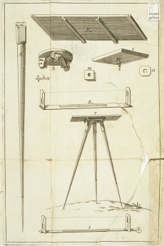
Plane Table
From Inventions
| Line 15: | Line 15: | ||
Ceneri, Angelo Maria. ''L'uso dello strumento geometrico detto la tavoletta pretoriana proposto e ampliato: opera postuma del sig. Angelo Maria Ceneri... in cui s'insegna il modo di misurare con questo strumento linee, angoli e piani e di più la maniera di renderlo idoneo e di usarlo nelle misure dell'altimetria: aggiuntavi la Pratica del parallelogrammo trigonometrico per rilevare le quantità superficiali delle figure rettilinee colle dimostrazioni geometriche sopra delle quali è fondata questa operazione e quella del parallelogrammo del padre Cristoforo Scheiner per disegnare e trasportare le mappe in qualunque data proporzione''. In Bologna, nella Stamperìa di Lelio dalla Volpe, 1728. | Ceneri, Angelo Maria. ''L'uso dello strumento geometrico detto la tavoletta pretoriana proposto e ampliato: opera postuma del sig. Angelo Maria Ceneri... in cui s'insegna il modo di misurare con questo strumento linee, angoli e piani e di più la maniera di renderlo idoneo e di usarlo nelle misure dell'altimetria: aggiuntavi la Pratica del parallelogrammo trigonometrico per rilevare le quantità superficiali delle figure rettilinee colle dimostrazioni geometriche sopra delle quali è fondata questa operazione e quella del parallelogrammo del padre Cristoforo Scheiner per disegnare e trasportare le mappe in qualunque data proporzione''. In Bologna, nella Stamperìa di Lelio dalla Volpe, 1728. | ||
| - | |strumentiesistenti= [http://brunelleschi.imss.fi.it/museum/esim.asp?c=403022 Florence, Museo Galileo. Institute and Museum of the History of Science, inv. 3603.]<br /> | + | |strumentiesistenti= |
| + | - Museo Galileo, Institute and Museum of the History of Science, Florence <br> | ||
| + | [http://brunelleschi.imss.fi.it/museum/esim.asp?c=403022 Florence, Museo Galileo. Institute and Museum of the History of Science, inv. 3603.]<br /> | ||
| + | |||
| + | |||
| + | |||
| + | - The Science Museum, Londra<br> | ||
| + | [http://www.sciencemuseum.org.uk/objects/surveying/1933-7.aspx The Science museum, inv. 1933-7]<br> | ||
| + | |||
| + | |||
| + | - Museum of the History of Science, Oxford <br> | ||
| + | [http://emu.mhs.ox.ac.uk/Display.php?irn=334&QueryPage Museum of the History of Science, Oxford, inv. 37998]<br> | ||
| + | [http://emu.mhs.ox.ac.uk/Display.php?irn=8374&QueryPage Museum of the History of Science, Oxford, inv. 18184]<br> | ||
| + | |||
| + | |||
| + | - Museo degli strumenti dell’instituo geografico militare, Florence <br> | ||
| + | [http://www.igmi.org/museo/strumento.php?sender=catalogo&id=65 Florence, Museo degli strumenti dell’instituo geografico militare, inv. 65]<br> | ||
| + | |||
| + | |||
| + | |||
| + | |link= | ||
| + | |||
| + | |||
| + | http://brunelleschi.imss.fi.it/museum/isim.asp?c=100400 (Italian) <br> | ||
| + | http://www.perugia3.it/files/tecniche/topografia/14Tavpretoriana.pdf (Italian) <br> | ||
| + | http://www.baden-powell.it/tecnica/Topografia/TAVOLETTA%20TOPO.HTML (Italian) <br> | ||
| + | http://museo.liceofoscarini.it/virtuale/tavoletta.phtml (Italian) <br> | ||
| + | http://www.tpub.com/engbas/11-24.htm (English)<br> | ||
| + | http://www.google.com/url?sa=t&source=web&cd=11&ved=0CD8QFjAK&url=http%3A%2F%2Fwww.una.edu%2Ffaculty%2Fgggaston%2FClasses%2Ffield_techniques%2FPlane%2520Table%2520Mapping.ppt&ei=n7FjTNuOE8Og4Qbx7cWdCg&usg=AFQjCNH1s2gpJ62zWXLj2swxA2WR_DETGw (Powerpoint presentation in english explaining the use of the instrument)<br> | ||
| + | http://uregina.ca/~sauchyn/geog411/mapping.html (English)<br> | ||
| + | http://www.pobonline.com/Articles/Features/bd47f0b5ba0f6010VgnVCM100000f932a8c0____ (English)<br> | ||
| + | |||
| + | |||
| + | |||
| + | |||
| - | |||
|immagini= <gallery widths=230 heights=368 perrow=3> | |immagini= <gallery widths=230 heights=368 perrow=3> | ||
Current revision as of 10:25, 8 September 2010
Name used since the eighteenth century, deriving from the inventor's pseudonym.
Contents |
Inventor
Giovanni Richter detto Praetorius
Historic Period
ca. 1590
Description
Invented by Giovanni Richter, known as Praetorius, the plane table, or "Praetorian table " (named for its inventor) represents an evolution of the board. In addition to the supporting stand and the vane with sights – accessories probably used already with its medieval prototype – the plane table is also fitted with a compass and a shadow square. It was used mainly for surveying and compiling corographic charts. The convenience of being able to plot the position angles of the sighted locations directly onto a sheet of paper and thus obtain an instant planimetric representation of the surface to be surveyed – a feature of more recent instruments as well, such as the holometer, the drum and the archimeter – ensured the widespread success of the plane table in the following centuries.
Bibliographical Resources
Noferi, Cosimo. Operationes tabulae per dioptram veteris instrumentum una cum demonstrationibus (ca. 1640). Firenze, Biblioteca nazionale centrale, Gal. 119.
Ceneri, Angelo Maria. L'uso dello strumento geometrico detto la tavoletta pretoriana proposto e ampliato: opera postuma del sig. Angelo Maria Ceneri... in cui s'insegna il modo di misurare con questo strumento linee, angoli e piani e di più la maniera di renderlo idoneo e di usarlo nelle misure dell'altimetria: aggiuntavi la Pratica del parallelogrammo trigonometrico per rilevare le quantità superficiali delle figure rettilinee colle dimostrazioni geometriche sopra delle quali è fondata questa operazione e quella del parallelogrammo del padre Cristoforo Scheiner per disegnare e trasportare le mappe in qualunque data proporzione. In Bologna, nella Stamperìa di Lelio dalla Volpe, 1728.
Existing Instruments
- Museo Galileo, Institute and Museum of the History of Science, Florence
Florence, Museo Galileo. Institute and Museum of the History of Science, inv. 3603.
- The Science Museum, Londra
The Science museum, inv. 1933-7
- Museum of the History of Science, Oxford
Museum of the History of Science, Oxford, inv. 37998
Museum of the History of Science, Oxford, inv. 18184
- Museo degli strumenti dell’instituo geografico militare, Florence
Florence, Museo degli strumenti dell’instituo geografico militare, inv. 65
Links (External)
http://brunelleschi.imss.fi.it/museum/isim.asp?c=100400 (Italian)
http://www.perugia3.it/files/tecniche/topografia/14Tavpretoriana.pdf (Italian)
http://www.baden-powell.it/tecnica/Topografia/TAVOLETTA%20TOPO.HTML (Italian)
http://museo.liceofoscarini.it/virtuale/tavoletta.phtml (Italian)
http://www.tpub.com/engbas/11-24.htm (English)
http://www.google.com/url?sa=t&source=web&cd=11&ved=0CD8QFjAK&url=http%3A%2F%2Fwww.una.edu%2Ffaculty%2Fgggaston%2FClasses%2Ffield_techniques%2FPlane%2520Table%2520Mapping.ppt&ei=n7FjTNuOE8Og4Qbx7cWdCg&usg=AFQjCNH1s2gpJ62zWXLj2swxA2WR_DETGw (Powerpoint presentation in english explaining the use of the instrument)
http://uregina.ca/~sauchyn/geog411/mapping.html (English)
http://www.pobonline.com/Articles/Features/bd47f0b5ba0f6010VgnVCM100000f932a8c0____ (English)
Images
Author of the entry: Filippo Camerota

