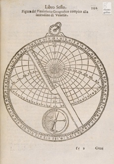
Geographic Planisphere
From Inventions
| Line 7: | Line 7: | ||
|data= 1544 | |data= 1544 | ||
| - | |descrizione= Developed and described by Oronce Finè, the instrument is a plane or planispheric astrolabe used to find the coordinates of places for geographical purposes. The mater contains only the disk with the stereometric projection of the celestial sphere and projection of the observer's horizon. It has no rete, but is equipped with compass and graduated diopter. The circumference is divided into four 90° sectors, used to measure the polar coordinates. | + | |descrizione= Developed and described by Oronce Finè, the instrument is a plane or planispheric astrolabe used to find the coordinates of places for geographical purposes. The mater contains only the disk with the stereometric projection of the celestial sphere and projection of the observer's horizon. It has no rete, but is equipped with [[compass]] and graduated [[diopter]]. The circumference is divided into four 90° sectors, used to measure the polar coordinates. |
|componenti= | |componenti= | ||
Revision as of 11:20, 19 July 2010
Name documented by Oronce Finè in 1544 (in Latin, planispaherium geographicum).
Contents |
Inventor
Oronce Finè
Historic Period
1544
Description
Developed and described by Oronce Finè, the instrument is a plane or planispheric astrolabe used to find the coordinates of places for geographical purposes. The mater contains only the disk with the stereometric projection of the celestial sphere and projection of the observer's horizon. It has no rete, but is equipped with compass and graduated diopter. The circumference is divided into four 90° sectors, used to measure the polar coordinates.
Bibliographical Resources
Finè, Oronce. Orontii Finaei ... Quadratura circuli, tandem inuenta et clarissim demonstrata; De circuli mensura et ratione circumferentiae ad diametrum, demonstrationes duae; De multangularum omnium et regularium figurarum descriptione, liber hactenus desideratus; De invenienda longitudinis locorum differentia, aliter qum per lunares eclipses, etiam dato quouis tempore, liber admodm singularis; Planisphaerium geographicum, quo tum longitudinis atque latitudinis differentiae, tum directae locorum deprehenduntur elongationes. Lutetiae Parisiorum, apud Simonem Colinaeum, 1544
Images
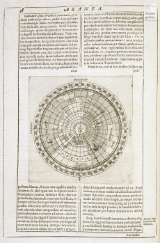
Mario Bettini. Apiaria vniuersae philosophiae mathematicae : in quibus paradoxa et noua pleraque machinamenta ad vsus eximios traducta et facillimis demonstrationibus confirmata : opus non modo philosophis mathematicis, sed & physicis, anatomicis, militaribus viris, machinariae, musicae, poëticae, agrariae, architecturae, mercaturae professoribus &c. vtilissimum, curiosissimis inuentis refertum figuratum aereis. Bologna, 1645, p.38 |
Author of the entry: Filippo Camerota


