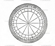
Horizon
From Inventions
Name adopted by the inventor deriving it from the armillary sphere accessory of the same name. From the Greek orizon (that which terminates).
Contents |
Inventor
Leon Battista Alberti
Historic Period
ca. 1436
Description
Goniometer instrument described by Leon Battista Alberti for transferring the measurements of a statue from the model to the stone, as well as for surveying and topographical drawing. It consists of a disk with diameter of one braccio (58.36 cm) divided along the circumference into 48 degrees of 4 minutes each. The instrument is used to measure the position angles of various places sighted in relation to a known station, by visually aligning the object, the centre of the instrument and a plumb line held in the operator's hand. A compass serves to position the horizon with the 0° turned toward Tramontana (the magnetic North Pole), so that the position angle of each place, read in relation to 0°, takes the name of polar coordinate. The position of a point in space is determined by measuring its polar coordinates in relation to two known stations. The point thus represents the vertex of a triangle whose base is the distance between the two stations. To draw a topographic map (planimetric position of the points in zenithal projection), the polar coordinates are transferred onto a sheet of drawing paper using two goniometers similar to the horizon, placed at the points that represent the two known stations in scale. Each place lies at the intersection of the lines extending from the centres of the goniometers toward the angles corresponding to its polar coordinates. The distance of various places from the main station can thus be measured directly on the sheet of paper. In his Descriptio Urbis Romae (1443-1448) Alberti adds to the horizon a radius divided into 50 degrees, which represents a distance measurement scale, furnishing the cartographer with data on the position angle of each place and its distance from the centre of the instrument. The topographical map is thus drawn within the circumference of the horizon, whose centre represents the main station, bringing the radius each time onto the various angles measured and marking the position of the corresponding points on the distance scale. An instrument similar to the horizon, a 360° graduated circle with a graduated radius, was used by sixteenth-century Viennese cartographers to enlarge charts or construct corographic maps transferring the coordinates of the places from a terrestrial globe. This method is found also in the treatise on perspective by Daniele Barbaro, who advises that it should be used with two semi-circles of different size, to reproduce or enlarge preparatory drawings for paintings. Another variant, square in shape, is illustrated in a manuscript by Giacomo Contarini, who specifies its use "to put things in drawings easily", by transferring measurements taken with the bossolo vivo, that is, the surveying compass.
Bibliographical Resources
Alberti, Leon Battista, Descriptio urbis Romae, a cura di Luigi Vagnetti, in «Quaderni dell'Istituto di Elementi di Architettura e Rilievo dei Monumenti di Genova», 1, 1968, pp. 23-80.
Alberti, Leon Battista, Ludi rerum mathematicarum, a cura di Cecil Grayson, in L.B. Alberti. Opere volgari, 3 voll., Bari, Laterza, 1960-73, III, pp. 133-173.
Vagnetti, Luigi. La Descriptio Urbis Romae: contributo alla storia del rilevamento architettonico e topografico, in «Quaderni dell'Istituto di Elementi di Architettura e Rilievo dei Monumenti di Genova», 1 (1968), pp. 23-80.
Barbaro, Daniele, La pratica della perspettiva, Venezia 1569, Parte IX, cap. V.
Bennet-Durand, Dana, The Vienna Klosterneuburg map corpus of the fifteenth century. A study in the transition from medieval to modern science, Leida, E.J. Brill, 1952.
Contarini, Giacomo, Figure d'Istromenti matematici e loro uso, ms. (ca. 1590), Oxford, Bodleian Library, Canon. Ital. 145, c. 14.
Images
Author of the entry: Filippo Camerota

